
Hello everyone, welcome to Micromine tutorial. In this article, I am going to show you how to create a new string file in Micromine. String file represents a vector file. You can save line, polyline…

KML file is a common file that Google Earth uses. Well, not only Google Earth, many GIS software supports KMLfile. In this article, I will show you how to import and export KML file in…
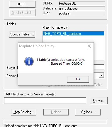
PostGIS is a great spatial database that supports various GIS applications such as Mapinfo Professional, Global Mapper, ArcGIS, QGIS and many more. In this article, I am going to show you how to export layer…

In most cases, you will need to have an ODBC Connection for PostgreSQL. If you are working with GIS software, mostly you will need to have a ODBC Connection. In this article, I am going…