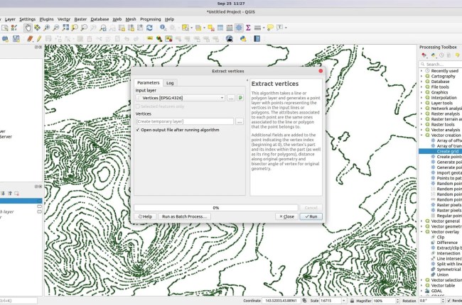
GIS Tutorial
  • Home
  • About
  • Contact

Popular Posts

How to open Mapinfo TAB file on QGIS
QGIS,

How to open Mapinfo TAB file on QGIS

by adminJanuary 1, 20181 comment
How to Export Layer to Shapefile on QGIS
QGIS,

How to Export Layer to Shapefile on QGIS

by adminSeptember 21, 2018no comment
How to Create a GeoPackage on QGIS 3.2
QGIS,

How to Create a GeoPackage on QGIS 3.2

by adminJuly 25, 2018no comment
How to convert polyline to polygon on QGIS 3.0
QGIS,

How to convert polyline to polygon on QGIS 3.0

by adminJune 12, 2018no comment

Category List

  • ArcGIS (83)
  • Database (58)
  • Free Spatial Data (2)
  • General (6)
  • Geoserver (2)
  • GIS Software (23)
  • Global Mapper (20)
  • Leapfrog Geo (16)
  • Linux (9)
  • macOS (2)
  • Mapinfo (40)
  • Micromine (32)
  • Oracle (6)
  • Programming (8)
  • QGIS (105)
  • Software Review (2)
  • Surfer (2)
  • Uncategorized (6)

Follow Us

Instagram

Instagram has returned invalid data.
GIS Tutorial
  • Home
  • About
  • Contact
Database,

How to Install Microsoft SQL Server Driver for Tableau in Apple Silicon Mac

by admin2 weeks agono comment
Database, Oracle,

Step by Step Installing Oracle Spatial Studio on Windows Server 2022

by admin2 months agono comment
Geoserver,

Install GeoServer on Windows 11

by admin2 months agono comment
Micromine,

Micromine Tutorial – Create a New Drillhole Database

by adminSeptember 19, 2018no comment

Hello everyone, welcome to another Micromine Tutorial. Today, I am going to show you how to create a new Drillhole database on Micromine. On this tutorial, I am using an old version of Micromine 11. If you are using newer version, you still can use this tutorial to create a

Micromine,

Micromine Tutorial – Export to Excel File

by adminSeptember 19, 2018no comment

Hello everyone, welcome to Micromine Tutorial. Today, we are going to learn how to export to Excel file from Micromine. I am using Micromine version 2013 full version and this should be the same with any version of Micromine. Micromine supports various data types including Microsoft Excel. On this tutorial,

Database, Mapinfo,

Working with PostGIS Database on MapInfo Professional

by adminSeptember 19, 2018no comment

PostGIS is a great spatial extension for PostgreSQL server. This extension enables us to store spatial datasets directly to PostgreSQL database from various GIS software. On this article, I am going to show you how to work with PostGIS database on Mapinfo Professional. There are few things we need to

Micromine,

How to Export Micromine Data to CSV Format

by adminSeptember 17, 2018no comment

Welcome to Micromine Tutorial. Today, I am going to show you how to export Micromine data file to CSV (Comma delimited file). Not many other GIS software can read Micromine data file (.DAT). But when we export the data to a more general format such as CSV, then we can

Database,

How to Create a New SQL Server ODBC Connection on Windows 10

by adminSeptember 17, 2018no comment

Welcome to Free GIS Tutorial blog. Today, I am going to show you how to create a new SQL Server ODBC Connection on Windows 10. Why you should know this thing? There are many GIS software that supports many databases but needs ODBC to work. For example, in Micromine, and

  • Prev
  • 1
  • 2
  • 3
  • …
  • 54
  • 55
  • 56
  • 57
  • 58
  • 59
  • 60
  • 61
  • 62
  • 63
  • 64
  • 65
  • 66
  • …
  • 75
  • 76
  • 77
  • Next

Trending

  • How to Install Microsoft SQL Server Driver for Tableau in Apple Silicon Mac

    How to Install Microsoft SQL Server Driver for Tableau in Apple Silicon Mac

    2 weeks ago
  • Step by Step Installing Oracle Spatial Studio on Windows Server 2022

    Step by Step Installing Oracle Spatial Studio on Windows Server 2022

    2 months ago
  • Install GeoServer on Windows 11

    Install GeoServer on Windows 11

    2 months ago
  • How Enable GeoRaster Support on Oracle Database Schema

    How Enable GeoRaster Support on Oracle Database Schema

    2 months ago

Ads


Ads


Pages