GIS Tutorial
  • Home
  • About
  • Contact

Popular Posts

How to open Mapinfo TAB file on QGIS
QGIS,

How to open Mapinfo TAB file on QGIS

by adminJanuary 1, 20181 comment
How to Create a GeoPackage on QGIS 3.2
QGIS,

How to Create a GeoPackage on QGIS 3.2

by adminJuly 25, 2018no comment
How to Export Layer to Shapefile on QGIS
QGIS,

How to Export Layer to Shapefile on QGIS

by adminSeptember 21, 2018no comment
How to convert polyline to polygon on QGIS 3.0
QGIS,

How to convert polyline to polygon on QGIS 3.0

by adminJune 12, 2018no comment

Category List

  • ArcGIS (75)
  • Database (34)
  • Free Spatial Data (2)
  • General (5)
  • GIS Software (20)
  • Global Mapper (20)
  • Leapfrog Geo (15)
  • Mapinfo (40)
  • Micromine (28)
  • Programming (2)
  • QGIS (98)
  • Software Review (1)
  • Surfer (2)
  • Uncategorized (4)

Follow Us

Instagram

Instagram has returned invalid data.
GIS Tutorial
  • Home
  • About
  • Contact
QGIS,

How to Add WMTS Layer on QGIS

by adminFebruary 14, 2018no comment
2
Shares
Share on FacebookShare on Twitter
qgis tutorial

WMTS (Web Map Tile Service) is an online service where we can get some specific data from the online data provider. To learn more about WMTS, please visit this page. Most modern GIS software support both WMS and WMTS. For example Datamine Discover (Mapinfo), Global Mapper and also QGIS. The WMTS server must be added to the particular GIS Software first.

Below is the Japan geological map (WMTS) loaded in QGIS.

wmts geological map on qgis.png

You must be connected to the Internet in order to use WMTS. You can see how to add WMTS on QGIS below.

Go to Layer | Add Layer | Add WMS/WMTS Server 

On the Add WMTS layer window, click New to add new WMTS server. Give a name for the new server and then type or paste the URL for the WMTS server.

add wmts qgis.png

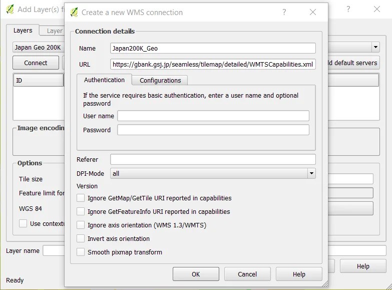
Click OK to continue. Then, click Connect to open the connection with the server.

add wmts qgis 2.png

Depends on the WMTS server you add, there might be extra step before we can add the WMTS layer to QGIS.

add wmts qgis 3.png

Don’t forget to check out our Free QGIS Tutorial for Beginners.

qgis tutorialwmts
Previous

How to Import Mapinfo Table to Micromine

February 14, 2018
Next

How to Display Points in Vizex in Micromine

February 15, 2018

Leave a Reply Cancel reply

Trending

  • How to Extract Raster Value to Point Layer in ArcGIS Pro

    How to Extract Raster Value to Point Layer in ArcGIS Pro

    1 week ago
  • How to Convert 5 GB Tiff into JPEG Easily

    How to Convert 5 GB Tiff into JPEG Easily

    2 weeks ago
  • Finally, I Can Run Oasis Montaj on My Macbook Pro M1

    Finally, I Can Run Oasis Montaj on My Macbook Pro M1

    2 weeks ago
  • How to Run ArcGIS Pro on Macbook Pro M1 and M2

    How to Run ArcGIS Pro on Macbook Pro M1 and M2

    2 weeks ago
  • ArcGIS
  • Database
  • Free Spatial Data
  • General
  • GIS Software
  • Global Mapper
  • Leapfrog Geo
  • Mapinfo
  • Micromine
  • Programming
  • QGIS
  • Software Review
  • Surfer
  • Uncategorized

Ads


Ads


Pages