
Micromine supports various file types. It also supports external GIS data sources such as Mapinfo, ESRI Shapefile, Google Earth KML and many more. As a part of our Micromine tutorial, we will show you how to import Mapinfo Table into Micromine. When we import Mapinfo to Micromine, all spatial and attribute information are preserved.
On this example, we will import a table called Tut_Collar which contains points.

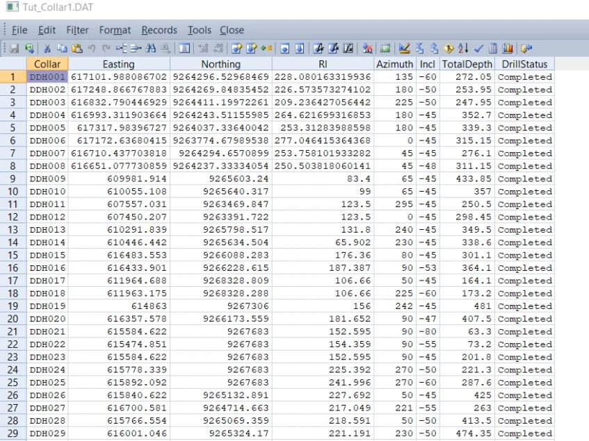
Data Browser

To import Mapinfo Table to Micromine, do the following on Micromine
Go to File | Import | Vector (CAD, GIS, GPS) Data

Specify the Mapinfo Table and give a name for the output. If the data source is point, we recommend to save it as Data file. If the source is line or polyline, use String file instead. Finally, the import process is complete. You can open, edit the file on Micromine.
[…] Hello everyone, welcome to Free GIS Tutorial website. Today we are going to learn how to create DTM from String file on Micromine. Micromine is a great GIS software that can easily convert or create DTM from string file. Before we can create DTM file, make sure you have Z information on the file. Z values can be elevation, geochemistry and other type of data. On this example, I have elevation contour string file I imported from Mapinfo. […]
[…] In this article, I am going to show you how to open the Mapinfo file in Micromine. You can either import the Mapinfo table into Micromine format or simply display it in Vizex without having to import. If the table has an elevation or Z […]